District Profile
Bijnor is a district of Uttar Pradesh state of India. Bijnor city is the district headquarters. The Uttar Pradesh Government wants Bijnor to be included under National Capital Region (NCR) due to its close distance from Delhi; the demand for inclusion of Bijnor in the NCR has been raised.
Geography
Bijnor occupies the north-west corner of the Moradabad Division (historically, Rohilkhand or Bareilly region), and is a roughly triangular stretch of country with its apex to the north. The western boundary is formed throughout by the deep stream of the river Ganges, beyond which lie the four districts of Dehradun, Saharanpur, Muzaffarnagar and Meerut, all belonging to the Meerut Division.
The extreme parallels of north latitude are 29° 2' and 29° 58' and of east longitude 78° 0' and 78° 57'. The total area of the district is liable to change slightly from time to time by reason of the erratic action of the Ganges and Ramganga: in 1906 it amounted to 1,145,272 acres (1789.5 square miles, 4634.75 km²) the average for the last five years being 1,147,967 acres (4,645.66 km²). There remains the low fringe of Khadir along the Ganges to the west. This generally resembles the lowlands that skirt the rivers of the interior, the low flats which adjoin the stream itself being purely alluvial in character, while above them rises a terrace of higher ground extending inland as far as the chain of stagnant morasses lying immediately under the bangar cliff.
Demographics
According to the 2011 census Bijnor district has a population of 3,683,896, roughly equal to the nation of Liberia or the US state of Oklahoma. This gives it a ranking of 74th in India (out of a total of 640). The district has a population density of 808 inhabitants per square km (2,090/sq mi). Its population growth rate over the decade 2001-2011 was 17.64%. Bijnor has a sex ratio of 913 females for every 1000 males, and a literacy rate of 70.43%.
General District Profile
|
Particular
|
Area (ha)
|

|
|
Reported Area
|
464545
|
|
Pasture Land
|
482
|
|
Horticultural Area
|
3148
|
|
Usar & Non-Agricultural land
|
4037
|
|
Cultivable Barren Land
|
3814
|
|
Other Fallow Land
|
3530
|
|
Forest Area
|
54898
|
|
Current Fallow Area
|
3496
|
|
Other than agriculture activity
|
55188
|
|
Net Cultivated Area
|
335952
|
|
Gross Irrigated area
|
401000
|
|
Net Irrigated area
|
308000
|
Rainfall and Temperature
Bijnor features a hot to moderate in summer and cool to colder climate. The city features cold winters, hot summers and a rainy season. However, the monsoons, though substantial in Bijnor, are not quite as heavy as the monsoon in other parts of India. Bijnor district receives average 100-110 cm rainfall. The major rainfall received during month of June to September. The average temperature ranges between 10c (during Dec. and Jan.) to 480C (during May and June).
The socio-economic & technological profile of agriculture in the area
|
Existing Farming System
|
Introduced Farming Systems
|
- Sugarcane Ratoon - Wheat
- Paddy - Wheat
- Paddy - Wheat - Sugarcane
- Sugarcane - Horticulture
|
- Early Basmati - Sugarcane - Ratoon
- September sown sugarcane with intercrops -Ratoon - Wheat
- Early Basmati -Mustard - Sugarcane - Ratoon
- Spring sugarcane with vegetables intercrops - Ratoon
|
Major farming systems/enterprises
- Integrated agriculture farming systems
- Integrated crop-livestock-fish farming systems
- Dairy farming systems
- Agro-forestry systems
- Agri-Horticulture farming systems
|
SN
|
Agro-climatic Zone
|
Agro-ecological situations based on soil & topography
|
Characteristics
|
|
1
|
AES 1 (Bhabar & Tarai Zone)
|
The Topography of Bijnor district is mainly a plain. The district has a pleasing climate with cool and foggy winter and generally hot and humid summer. The wet session starts from July to October during which the district receives rainfall. The temperature of the district is varies from 480C in summer and 30C in winter. These districts have the highest density of population which gives the lowest per capita land. The other two regions, the central and the western are comparatively better with a well-developed irrigation system
|
- The soils are coarse to medium in texture, moderately well drained, consistently deep and neutral to slightly alkaline in nature
- Climate of the zone in general is subtropical type
- The maximum temperature of the district was 450C while minimum was found to be 0.60C
- The average rainfall is 1400 mm. Eighty three percent of rains are received from south- west monsoon from June to September
- The major crops of the zone are sugarcane, rice, wheat, mustard & urd etc.
- The soils are low to medium in available phosphorus, medium to high in organic carbon
|
Major problems identified through PRA
- Low yield in sugarcane crop due to heavy infestations of old variety, red rot, Top borer & weeds
- Low yield in rice due to heavy infestations of Blast disease, Stem borer, Leaf folder & weeds
- Low yield in wheat crop due to heavy infestation of weeds
- Low yield in mustard crop due to old varieties & infestation of aphid
- Low yield in vegetable crops i.e. cauliflower, Brinjal, Tomato & Onion due to old varieties and imbalance use of nutrients
- Low yield in Mango & Guava due to old orchard imbalance use of nutrients and
- heavy infestation of shoot gall maker and dieback disease
- Low income and unemployment of rural youth
|
SN
|
Soil type
|
Characteristics
|
Area in ha
|
|
1
|
Clay loam
|
Fine-grained minerals, organic matter medium, variable range of water content, clay minerals.
|
223752
|
|
2
|
Sandy loam
|
Fertile soil with rich nutrient, organic matter medium to high suitable for all arable crops.
|
172428
|
Topography
The Topography of Bijnor district is mainly a plain. The district has a pleasing climate with cool and foggy winter and generally hot and humid summer. The wet session starts from July to October during which the district receives rainfall. The temperature of the district is varies from 480C in summer and 30C in winter. These districts have the highest density of population which gives the lowest per capita land. The other two regions, the central and the western are comparatively better with a well-developed irrigation system.
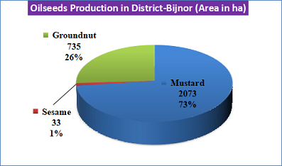
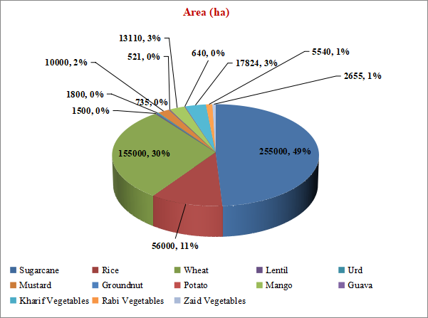
Area, Production and Productivity of Major Crops cultivated in the district
|
Crop
|
Area (ha)
|
Productivity (q./ha)
|
|
|
Sugarcane
|
255000
|
901.00
|
|
Rice
|
56000
|
28.05
|
|
Wheat
|
155000
|
39.25
|
|
Lentil
|
1500
|
8.11
|
|
Urd
|
1800
|
13.93
|
|
Mustard
|
10000
|
14.11
|
|
Groundnut
|
735
|
|